Why Annotated Maps Matter
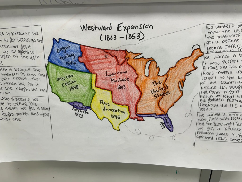
One strategy that has become completely locked in for me over the years is annotated maps. I have used annotated maps with Westward Expansion, the Crusades, the French and Indian War, European Exploration and Colonization, and the Causes of the Civil War. No matter the topic, the goal always stays the same. I want students to see the relationship between geography and history instead of viewing maps as something separate from the actual content.
Too often students look at maps as a quick reference tool instead of historical evidence. They memorize locations for a quiz, but never fully think about why rivers mattered, why cities developed where they did, why territories became contested, or why expansion happened in certain directions. Annotated maps slow students down and force them to think about those relationships while they are building the map itself.
The activity also combines so many important skills together naturally. Students are researching, organizing information, analyzing cause and effect, discussing ideas, creating visuals, and continuously revisiting a larger historical question. The map becomes much more than a geography assignment. It becomes a thinking activity.
Starting With a Driving Question
The entire process starts with a compelling or driving question. Questions like:
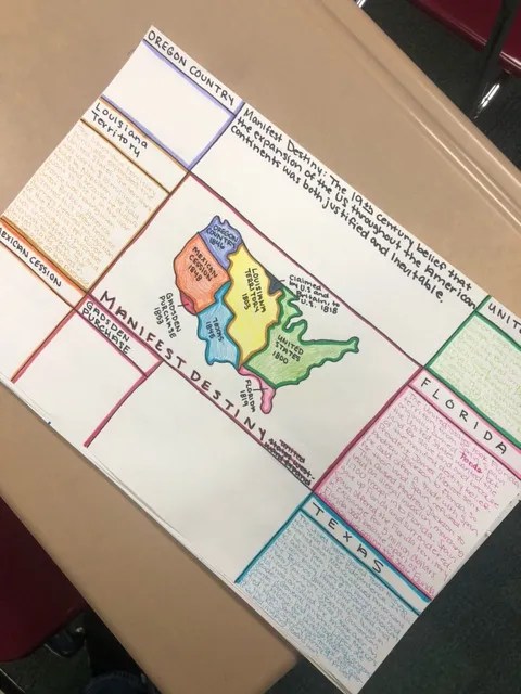
- How did manifest destiny contribute to Westward Expansion?
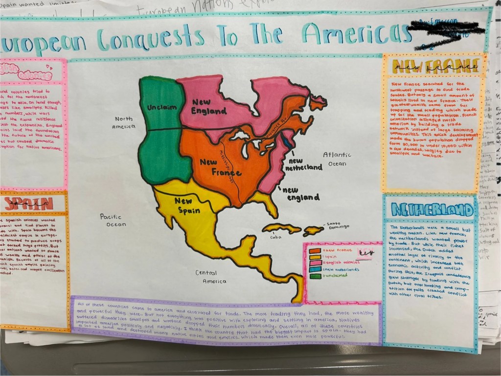
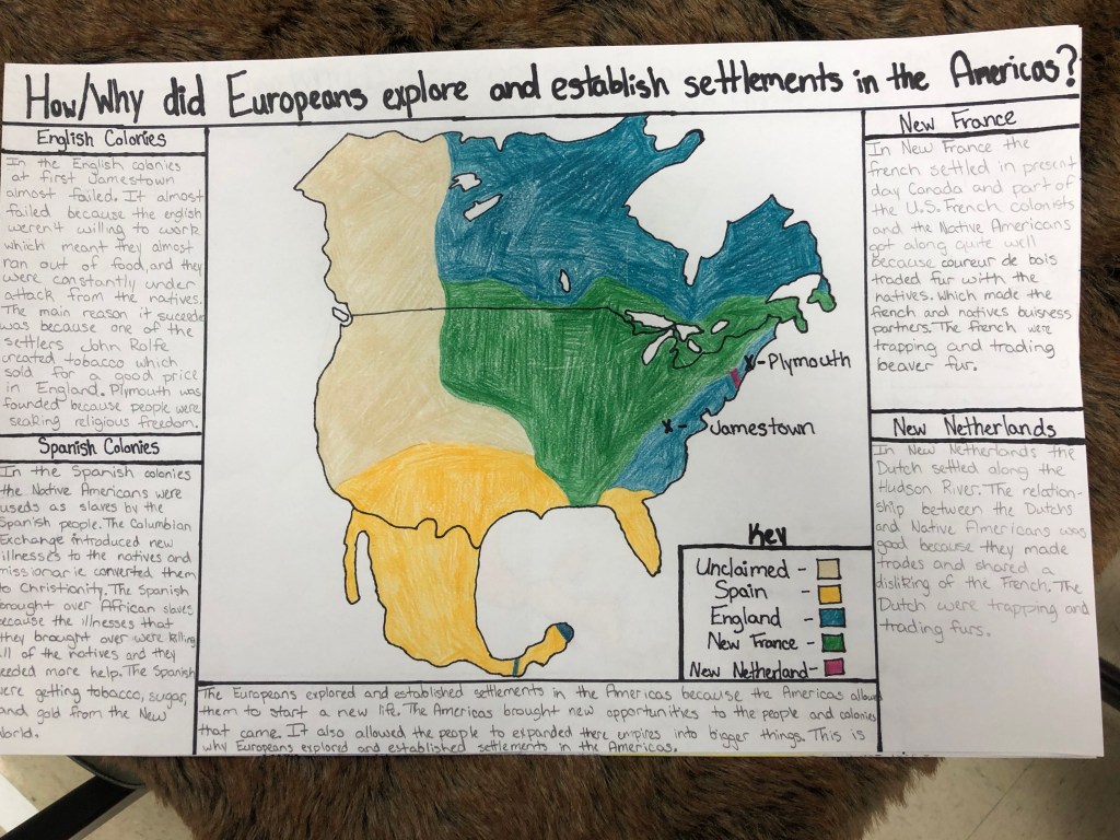
- How did Europeans explore and colonize North America?
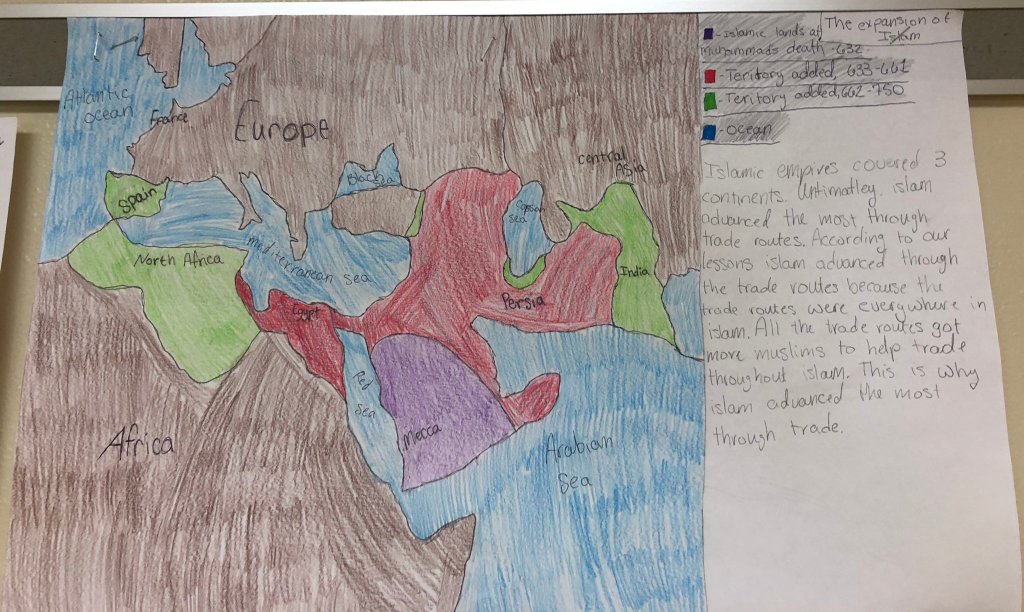
- Which led most to the expansion of Islam – innovation, trade, or conflict?
The question gives the map purpose. Students are not simply drawing locations because the teacher told them to. Every label, annotation, and piece of research should connect back to answering the larger historical question.
I think the driving question changes the quality of student thinking immediately. Students stop seeing the map as a worksheet and start seeing it as evidence that helps explain historical events. Instead of memorizing isolated facts, they begin making connections between geography and the decisions people made throughout history.
Hand Drawing the Maps
I also have students hand draw the maps. No tracing and no pre-made outlines. I hear complaints every single time we start, but I continue doing it because students pay far more attention to geography when they physically create the map themselves.
The process of drawing the map forces students to interact with the geography instead of passively looking at it. Students slow down and begin recognizing patterns they normally would not notice if they were simply filling in labels on a printed worksheet. I also think there is value in students physically creating something themselves instead of instantly relying on technology to do the work for them.
The maps are rarely perfect, but perfection is not the goal. The goal is building understanding through the process of creating the map.
Building the Annotations Through EduProtocols
Once the maps are drawn and labeled in the center of the page, students begin building annotations around the outside of the map. Those annotations might include statistics, explanations, cause and effect relationships, evidence from readings, visuals, symbols, or short written responses connected to the driving question. The annotations are what transform the activity from a geography worksheet into a historical thinking activity.
What I really like about annotated maps is how naturally they pair with EduProtocols. The annotations do not need to come from one giant lecture or packet. Instead, students build their annotations from the learning and research they complete throughout the unit using different protocols.
In the past, I have done a series of CyberSandwiches where students read, discussed, and summarized information connected to the driving question. As students built summaries throughout the week, they continuously referred back to those summaries while creating annotations around the map. This worked really well because students already had manageable chunks of information prepared instead of trying to start the entire map from scratch at the very end.
I have also paired annotated maps with Thick Slides. Students completed a series of Thick Slides connected to different parts of the unit, then used those slides as references while building the annotations around their maps. The Thick Slides helped students organize important information, visuals, and evidence before transferring their thinking onto the poster itself.
One pairing that worked especially well was using the ParaFLY EduProtocol before students annotated the maps. Students practiced paraphrasing information from readings, then transferred their paraphrased information directly onto the poster. This helped students avoid simply copying information word for word and forced them to process the content more carefully before adding it to the map.
A strategy I really liked using alongside ParaFLY involved rolling dice to help students practice concise writing. I used a dice with numbers ranging from 10 to 30. After rolling the dice, students had to annotate and explain information using that exact number of words. The structure forced students to think carefully about word choice, summarize information clearly, and avoid adding unnecessary details. It also created a simple challenge that kept students engaged while practicing paraphrasing and summarizing skills.
The combination of annotated maps and EduProtocols works well because students are constantly revisiting information, discussing ideas, summarizing learning, and transferring knowledge into a visual format. Instead of the map becoming a standalone assignment at the end of the unit, it becomes the place where all of the learning throughout the week starts coming together.
Formative or Summative? Both Work.
One reason annotated maps have stayed locked in for me is because they are flexible. Sometimes students build the map over several days as a formative assessment where they continuously add new learning and revise their thinking throughout the unit. Other times the annotated map becomes the final summative assessment where students synthesize everything they learned into one product.
I have paired annotated maps with several EduProtocols where students answer the compelling question directly beside the map using evidence gathered throughout the unit. That combination works really well because students are visually organizing information while also practicing historical writing skills.
The finished products also give me a much clearer picture of student thinking than many traditional assessments. Students are organizing, connecting, explaining, and applying information instead of simply selecting answers on a multiple choice test.
Why the Structure Works
What I like most about annotated maps is that students are constantly doing something with the information. They are researching, organizing, discussing, connecting ideas, revisiting the driving question, and visually showing relationships between geography and history. Students begin recognizing that geography is not just background information. Geography shapes decisions, trade, migration, conflict, expansion, and power.
I also think annotated maps work well because they naturally keep cognitive load manageable. Instead of overwhelming students with a massive project all at once, students build understanding piece by piece while continuously connecting information back to the same central question. The map becomes an organizational structure for their thinking.
The structure also works because students create something meaningful while interacting with content from multiple angles. They are writing, drawing, researching, discussing, and analyzing all within the same activity.
Final Thoughts
At the end of the activity, students have something visual and tangible that represents their learning. More importantly, they begin seeing history differently. Historical events stop feeling random because students can physically see how geography influenced the story.
That connection between geography and history is why annotated maps have stayed completely locked in for me for years.