Introduction
This week, we started a new unit on Westward Expansion. Last year at this time, I was ahead of schedule and created a new unit on Andrew Jackson, but I decided not to do that unit this year because I am now three weeks behind schedule compared to where I was last year. To begin this new unit, I took the question directly from our textbook: “How justifiable was westward expansion?” I also added another question: “What role did Manifest Destiny play in westward expansion?” In Ohio, our standard suggests that students need to understand and be able to describe how the United States acquired territories such as Louisiana, Oregon, Florida, the Mexican Cession, and the Gadsden Purchase. My end goal with this unit was to have students continue to work on writing with claims, evidence, and reasoning, as well as be able to summarize and describe how we acquired different territories around the United States.
Monday – Quizizz, Geography Challenge
Tuesday – Sketch and Tell, Quizizz
Wednesday – Westward Expansion Territory Thick Slide
Thursday and Friday – Annotated Map
Monday
On Monday, I started off with a Quizizz featuring questions related to the entire unit we are going to study on Westward Expansion. This included topics such as the territories and the people that went out west. The quiz served as a pre-assessment to see where we were and what we knew and didn’t know. The average score across all classes was around 42%. Next, I took the geography challenge from TCI and used some AI to generate additional questions. The geography challenge was a nice way to introduce the students to Westward Expansion, allowing them to see a map and become familiar with the time and space in the context of the unit.
I took the questions from TCI, put them into a Google Doc, and then had AI generate two new questions, resulting in three different levels of the geography challenge for the multiple levels of students within my class. I was really impressed with AI and the questions it came up with for the geography challenge. I had it provide several different quotes from somebody who took a trail out west, and the students had to read the description and mark an X on the map where they thought the person was located. I thought this type of question was creative and pretty awesome. Here was one of the questions: “Read this quote and place a green X on your map at the location where you think it took place: ‘We followed the Oregon Trail along the Platte River for many miles. The landscape was flat and dusty, with few trees as far as the eye could see. The river guided us on, but provided little relief from the harsh prairie winds that parched our lips.'”
After 30 minutes, I collected the geography challenge. While the students were working on the geography challenge, I set up a Great American Race by writing different people, events, and topics on index cards and numbering them. At the end of the 30 minutes, I passed out an index card to each student and had them design a slide with three clues and a picture to set up the Great American Race for Tuesday’s class. This took less than 10 minutes.
Tuesday
On Tuesday, I handed back the geography challenge and told the students we were going to use these maps, so they had to hold on to them and be responsible for them. I also printed off all of the slides they designed for the Great American Race, stapled them together, and had the students get into groups of two to three people. I handed each group a packet of the slides they created, had them get out a piece of paper, and number it from one to 20.
This was a great way to introduce some of the events, people, and content associated with Westward Expansion that the students were getting ready to learn about. It was also a nice extension after the geography challenge. I gave the students 25 minutes to look up and find the answers for the 20 slides they created. Most groups got this done, but some groups did not. It’s always funny to me how they always assume this is easy because they feel like all they have to do is just type something into Google and they’ll get the answer; however, this is not the case. They have to know exactly the important words to type in to find the answer for what they want.
After the Great American Race, I looked at the results of the quizzes from the previous day and noticed that students were having trouble coming up with the answer for the Great American Race slides for annexation and cession. I anticipated this and had Sketch and Tell slides ready to go for these two words. We ended class with a Sketch and Tell on annexation and cession.
Wednesday
On Wednesday, now that we had the geography challenge and the Great American Race complete, it was time to dive a little deeper into the territories associated with Westward Expansion. I reminded the students of our essential question: “How justifiable was westward expansion?” To begin class, we looked up and completed a Frayer model for the word “justifiable.” I gave students three to four minutes to look it up, write a definition, find examples and non-examples, and use it in a sentence.
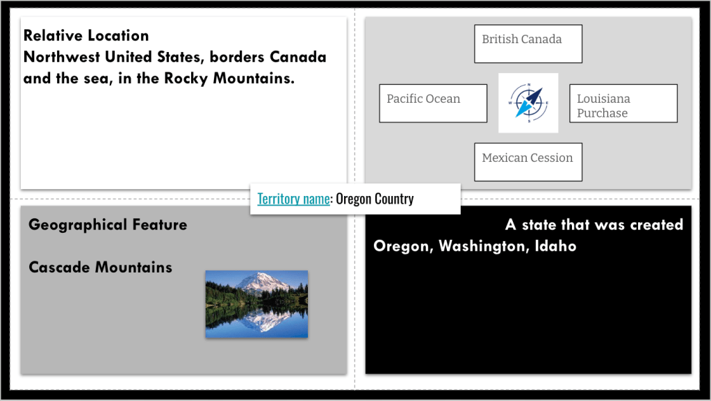
Next, I used an idea that I saw on the EduProtocols+ Hot Shot Show with Drew Skeeler. I used a geography template that I applied to a Frayer model. I had the students pick a territory from Westward Expansion, and they had to describe its relative location, use a compass to identify what was north, south, east, and west of the territory, find a geographical feature, and list a state that was created from the territory. I had the students use their geography challenge maps to help them with some of this, and I told them we were going to use that map again. This was a great way to help the students become familiar with their territory in a geographical context.
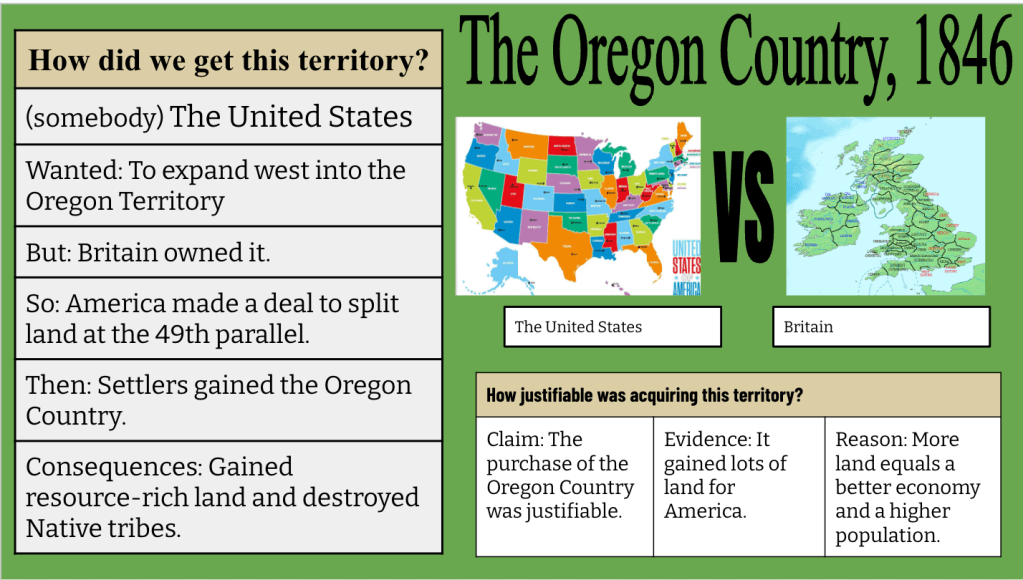
I then stated that the territory they chose was the territory they were going to create a Thick Slide about and share with the class. I had AI generate readings for all six territories and asked AI to provide context and details on how we got these territories and the consequences of each. I also mentioned our essential question in my prompt so AI could generate the readings to help students answer the question of how justifiable Westward Expansion was.
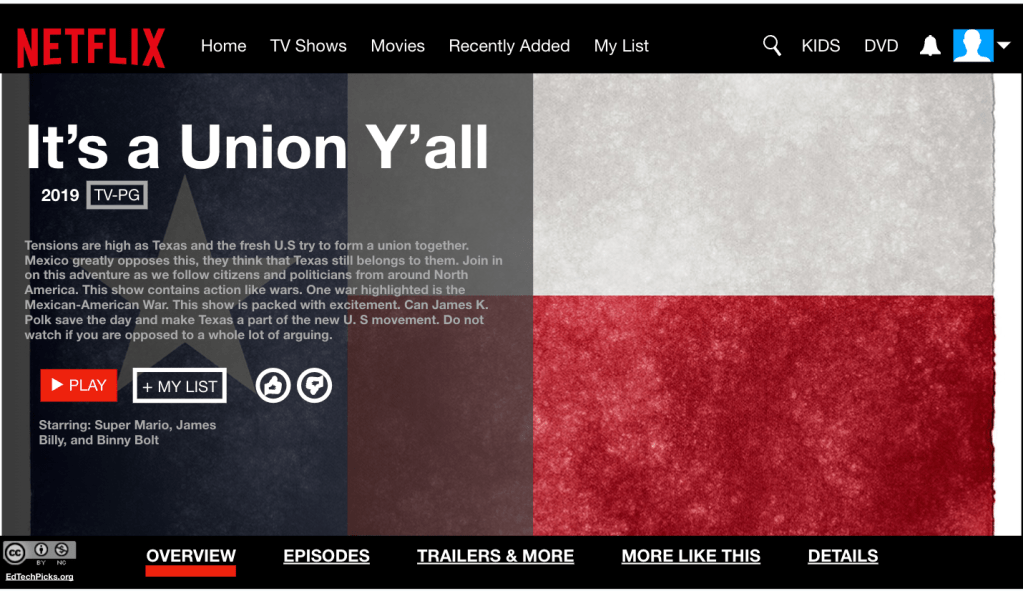
Students read about their territory and created a Thick Slide using the “Somebody Wanted But So Then” framework to retell how we got that territory. They provided two pictures and used some claim, evidence, and reasoning to answer the essential question. Reading and creating the slide took about 20 minutes. Once students were done, they shared a link to their slide through a Google Form, and I compiled all the slide links from the form into a Google Sheet and shared it with all of the classes. The last thing I had students do was take their territory and create a title and show description related to their claim, evidence, and reasoning from their Thick Slide. This was a simple way to end class for the last 10 to 15 minutes and a great way to incorporate some Depth of Knowledge Level 3 with the learning.


Thursday and Friday
On Thursday and Friday, I began class with a Quizizz because I ran out of time from the previous day. We were then going to start an annotated map, which I like to do with this unit because it fits with the standard and learning expectation of being able to summarize and describe how we got the territories during Westward Expansion. With an annotated map, you can either have the students hand draw a map or use a pre-made map and label it and cut it out. In this case, I had the students get out their map from the geography challenge, and I had them finish labeling the map with all six territories. Then, I had them glue the map to the center of a big piece of paper, and around the map, they were going to have to summarize and describe how we got the territories along with the consequences of it. Also, at the top, I had them write, “How justifiable was westward expansion?”
The idea of the annotated map is that you begin with the essential question in mind, work through the lesson, and then circle back to the original question at the very end, using evidence from all of your summaries to answer the essential question. To get their information, the students were going to use the slides that their classmates shared. I like doing this activity as it connects all my classes, and we are learning from each other. Plus, I like this lesson as I tell the students they must evaluate the sources that their classmates have created for them and ask themselves, “Is this a reliable, valid source which is going to give me the information that I need?” If not, then they should move on and find another source that they think is better.
I was hoping the annotated map would take two days, but we’re going to have to use a little bit of class time on Monday to finish them up. On these two days, we also did a little Fast and Curious with Quizizz, and the scores of the classes were really good. Based on the scores that I have seen, I really like this sequence of the geography challenge and EduProtocols for student learning.

