This week we continued with the Exploration and Colonies unit. We dove into Colonial Regions this week. I don’t focus on the individual 13 colonies because, to me, it’s not necessary. The idea in designing this lesson was having students understand how geography impacts the economy and various industries in the colonial regions.
When I set up my lesson, I created a fast and curious on Quizizz with 14 questions and paired it with a CyberSandwich. This is one of my favorite pairing of EduProtocols. I also used the unit as an opportunity to try out the Research Protocol created by my co-author Scott Petri. The Research Protocol led to the evaluation and creation of a summary slide. Finally, the students used their summary slide to create an airEMC advertisement to attract people to their Colonial Region.
Monday – Fast and Curious, Sketch and Tell
Tuesday – Fast and Curious, CyberSandwich
Wednesday – Research Protocol Sheet, Fast and Curious
Thursday – Research Protocol Summary Slide
Friday – Summary Slide, AirEMC (This is on www.emc2learning.com)
Monday
I used Monday as a way to introduce the Fast and Curious about colonial regions. The beginning class averages ranged from 42% to 53%. At the conclusion, I gave some feedback. This Fast and Curious included some vocabulary and content related questions. After giving some feedback, students started on a Sketch and Tell with some vocabulary.
The vocabulary within the Sketch and Tell related to the CyberSandwich reading for Tuesday’s class. The 4 words on the Sketch and Tell were:
- Mercantilism
- Democratic
- Economy
- Charter
Students had 20 minutes to create a sketch and write a definition in their own words. I set a timer for 5 minutes and reset the timer for each new slide. This was the 6th rep of Sketch and Tell this year, and the students keep improving.
At the conclusion of the Sketch and Tell, I ran the fast and Curious one more time. This time, class averages ranged from 68% to 75%.


Tuesday
Tuesday was the first rep of a CyberSandwich this year. My 1st and 8th periods I ran a traditional CyberSandwich using Google Slides. For my 3rd, 5th, and 7th period classes I ran the CyberSandwich using Nearpod. Why the difference? My middle three classes need a bit more control and Nearpod helps me provide that control.
On the CyberSandwich with Google Slides, I linked in a one page, TCI textbook section on the colonial regions. I also provide a paper copy as well. Here is my process for the Google Slide lesson:
- Students read and take notes for 10 minutes.
- Then students share their slide with a partner. (I have students share their slide with a partner after the reading because the sharing and moving is a distraction).
- Students discuss for 5 minutes.
- Then students spend 10 minutes writing a summary.
For my Nearpod lesson, I broke the reading into smaller sections because the students in my 3rd, 5th, and 7th periods need that. I linked each section to a collaboration board in Nearpod. I also added in some interactive, virtual reality slides showing geography of these regions. Here was my process for the Nearpod lesson:
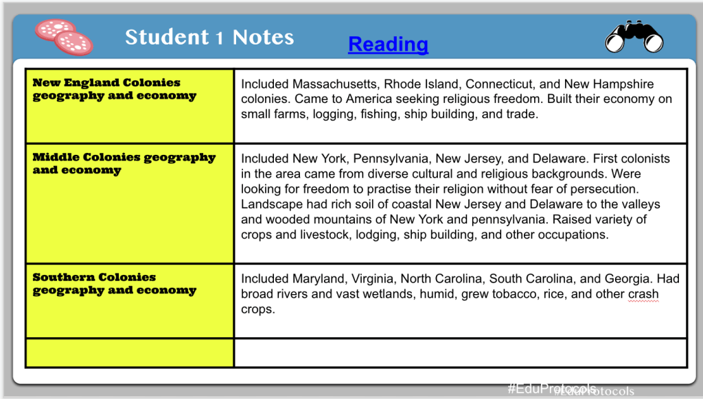
- Students read about the New England region and shared two facts on a collaboration board. (Students wrote down notes on a piece of paper.)
- Then students looked at a virtual reality slide showing a coastline in Maine. We noticed the rocky coast, trees, and hills discussed from the reading.
- Students read about the Middle region and shared two facts on a collaboration board.
- Then students looked at a virtual reality slide showing a small farm in Pennsylvania. We noticed the forest, hills, and fields.
- Students read about the Southern region and shared two facts on a collaboration board.
- Then students looked at a virtual reality slide showing a small tobacco farm.
- The last step was writing a summary for the impact of geography on the economy of each region. I used a Nearpod open question slide with a 10 minute timer. As soon as the timer ends, the question shuts down.
At the conclusion of both CyberSandwiches, everything was graded. Then we transitioned to a Fast and Curious. The class average range was 75% to 84%.


Wednesday
I went into school Wednesday morning wanting to do something different with my colonial regions lesson. Usually I tie in an annotated map, but I wanted something different. After some thought, I decided to use Scott Petri’s Research protocol from our book EduProtocols Social Studies Edition. I wanted this lesson to be an extension of the CyberSandwich from Tuesday. I also wanted the end goal (end creation) to be an advertisement to convince people to move to their colonial region.
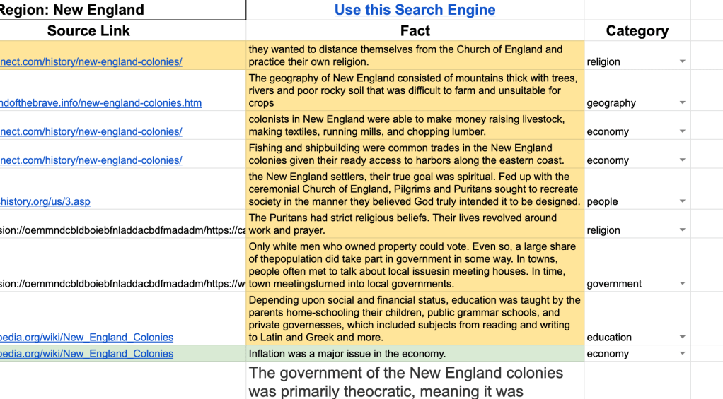
The first thing I created was a Google Sheet for students to collect their facts and information on colonial regions. I created a drop-down-menu column in the sheet so students could categorize their facts with geography, economy, people, religion, education, government.
My next step was creating my own customized Google search engine. Yes, you can create your own Google search engine. Visit this site: programmablesearchengine.google.com, give your search engine a title, and add your own links. It’s incredible. I linked my search engine into the Google Sheet.
When students arrived, I had them choose one of the colonial regions. I gave them 30 minutes to find 15 or more facts from 3 different sources. This , of course, was scaled down from Scott’s AP version. For 30 minutes, students copied and pasted facts. I liked that I added in the category column because it had the students reading their facts and pondering how they should categorize them.
This protocol was incredible. The students were engaged. I also loved that they were engaged with a Google Sheet. More students need to be using spreadsheets in multiple ways.


Thursday
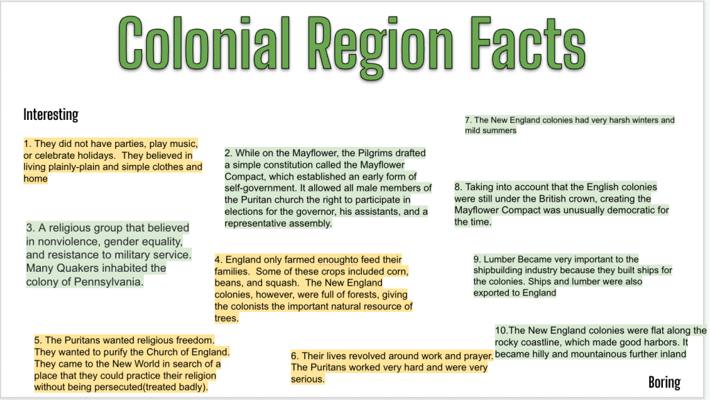
On Thursday, around 60% of students had all 15 facts ready to go. The next step in the process was having students rank their facts. I explained to them that copying and pasting was okay the first time around of fact collecting. However, in order to evaluate and rank facts, they need to read them, consider them, and rank them. The students ranked their facts from most interesting to most boring. Then I explained that basic knowledge such as people we ALL know, dates we ALL know would be considered boring in my book.
Students began to evaluate their information and copied their top 10 facts to the Research Protocol summary slide. Some students got creative and organized their facts, some just pasted facts, and other did what they could. This entire idea of this protocol seemed weird to them, but then again, most of how I run my class is weird to them. It’s taking a while for the kids to get used to me, but I’m making small breakthroughs.
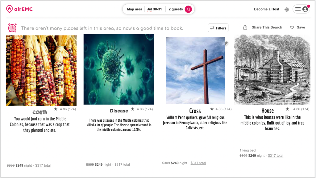
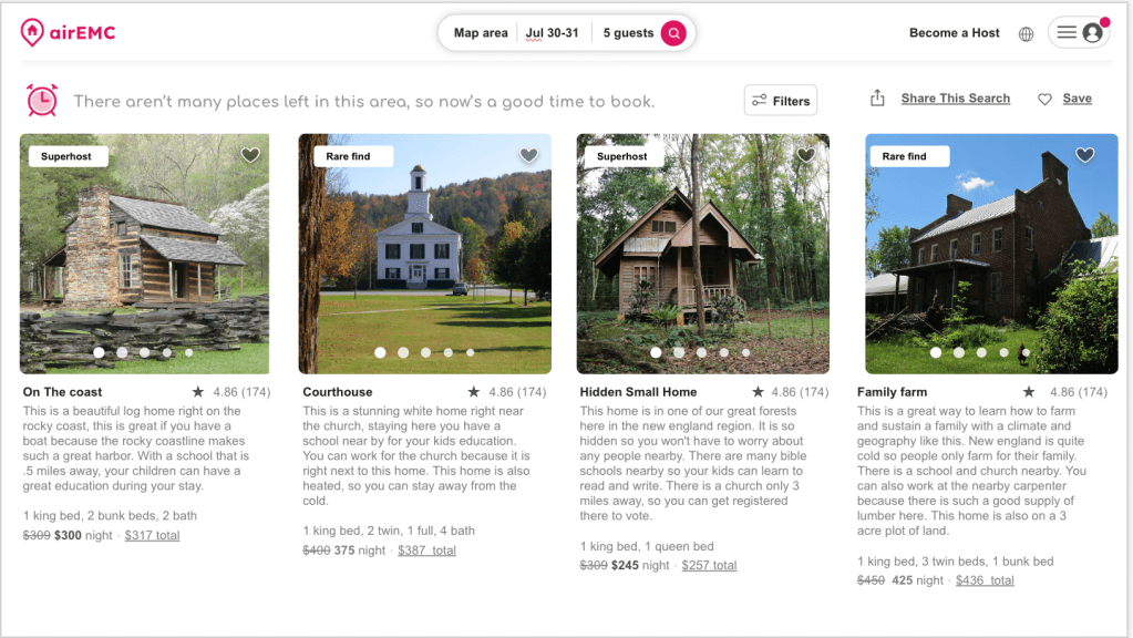
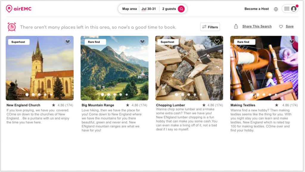
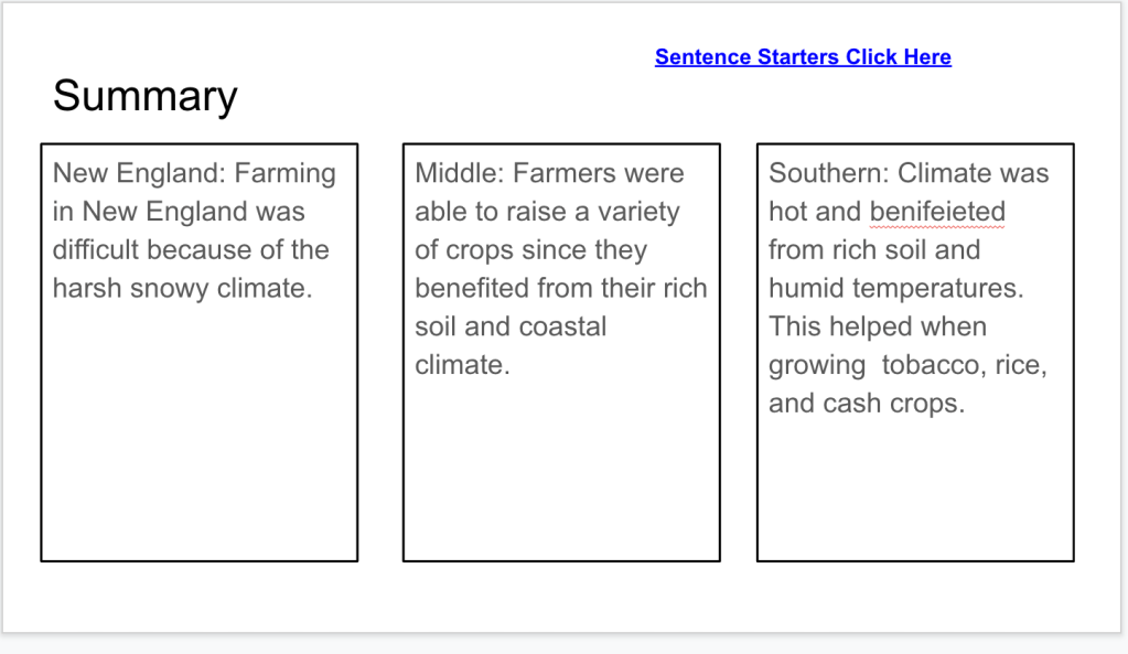
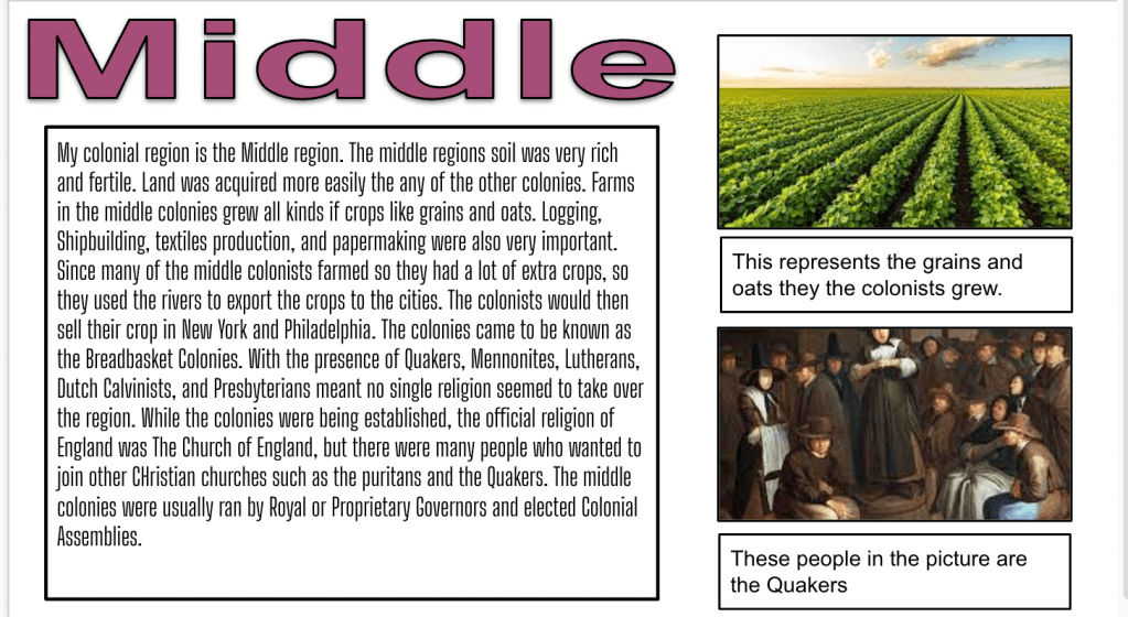
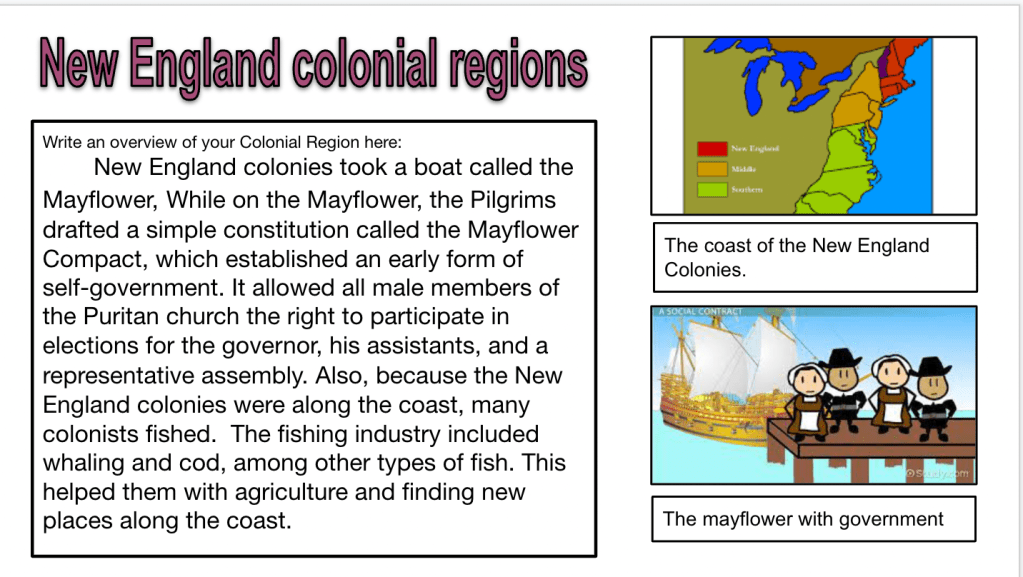
After students ranked their facts, I had them create a summary slide. On the summary slide, students wrote a summary, or overview of their region focusing on 4 categories (geography, economy, religion, education, government, or people). They added two picture with captions and a title. Here are some samples:


Friday
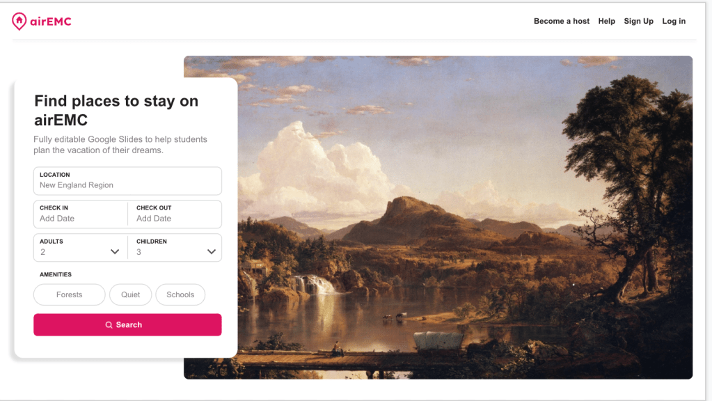
For the end product, I wanted to see what the students would create with the airEMC template (This is a template made to look like an airBnB site). The purpose was to convince people to move to your colonial region. However, as students began working, I feel like the message got lost and I threw too much at them at once. I established success criteria, but many students seemed lost. It may have been the original language on the slides of choosing a “home” or it could have been that they were not familiar with airBnB. Here are some examples: