This week was all about making westward expansion more engaging and interactive while reinforcing key historical concepts through EduProtocols. From annotated maps and Thick Slides to Map & Tell and Parafly, students used a variety of strategies to build knowledge, analyze sources, and develop writing skills. We started with a Great American Race to introduce westward territories, followed by a Map & Tell to break down the meaning of “54°40′ or Fight.” Parafly helped students strengthen their paraphrasing skills with key readings on Oregon, and a MiniReport paired with Class Companion gave them practice comparing sources on the Texas Revolution.
Monday/Tuesday/Wednesday – Frayer, Thick Slide
Thursday – Oregon Rack and Stack
Friday – Texas MiniReport
Monday, Tuesday, Wednesday
Monday through Wednesday were a mix of different activities. Some students were completing Restart Readiness ELA tests, which involved reading two passages, answering comprehension questions, and writing an essay. Others were catching up on missed work, either for ELA or social studies. For those working on social studies, I focused on building background knowledge about how the U.S. acquired its western territories.
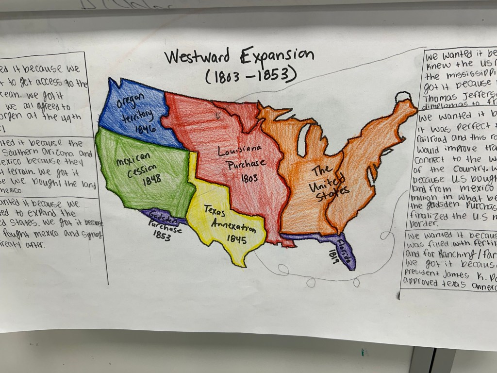
Mapping Westward Expansion
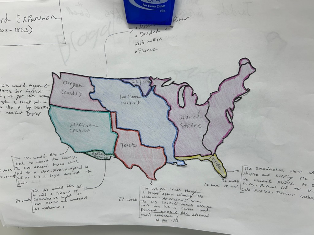
To start, students labeled and colored a map of westward territories, then cut it out and glued it to the center of a giant piece of paper. From there, they chose a specific territory—Louisiana, Texas, Oregon, the Gadsden Purchase, etc.—to analyze in depth.
Frayer Model + Thick Slides
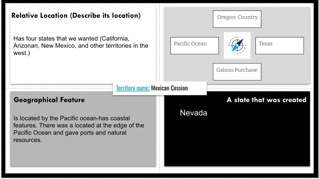
Using a Drew Skeeler template, students created a Frayer Model for their chosen territory:
- Relative location (what’s north, south, east, and west?)
- A geographic feature from the territory
- A state that came from the territory
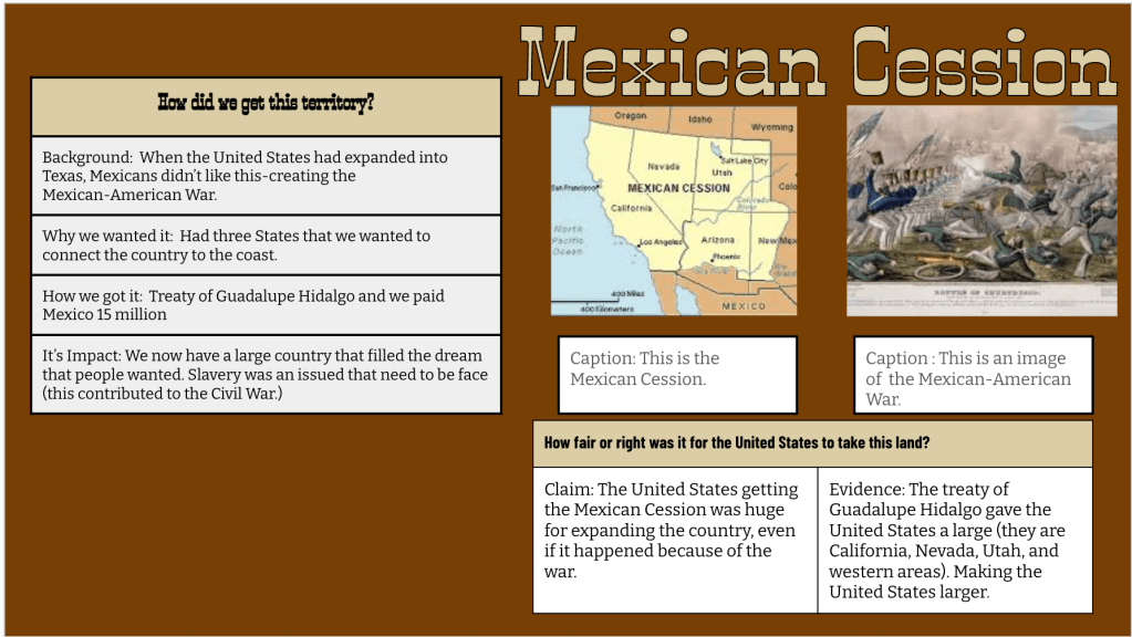
Then, students moved on to a Thick Slide, where they:
- Provided background information on the territory
- Explained why and how the U.S. acquired it
- Discussed its impact
- Wrote a claim on how justifiable the acquisition was, supported with evidence
- Added two pictures and a title
Students submitted their Thick Slides through a Google Form, which I compiled into a Google Sheet for reference.
Annotated Maps + Dice Challenge
On Wednesday, students took an initial Quizizz on how the U.S. acquired each territory. The class average across all periods was 49%—clearly, they needed more time with the content.
Enter the Annotated Map—a strategy that helps students apply history to geography the way they would annotate a text. Using the Google Sheet of Thick Slides, students pulled key information and wrote annotations around their maps explaining how and why the U.S. acquired each territory.
To combat copy-pasting, I introduced a dice challenge:
🎲 I rolled three dice—a 20-sided, 12-sided, and 6-sided—and the total determined how many words students had to use for each annotation. Each round, they had to summarize the acquisition using only that many words. This forced them to think critically, be selective with word choice, and paraphrase rather than copy directly.
At the end of class, we took the Quizizz again—this time, class averages jumped to 82%. Huge improvement, and it reinforced why layered, interactive learning beats simple memorization every time.
Thursday
Thursday’s lesson focused on how and why the U.S. acquired Oregon, along with the experiences of those who traveled west.
Gimkit Warm-Up
We started with a 5-question Gimkit about Oregon, running it for three minutes before I gave feedback. Then, we ran it again for two minutes—already, students were improving just from this quick retrieval practice.
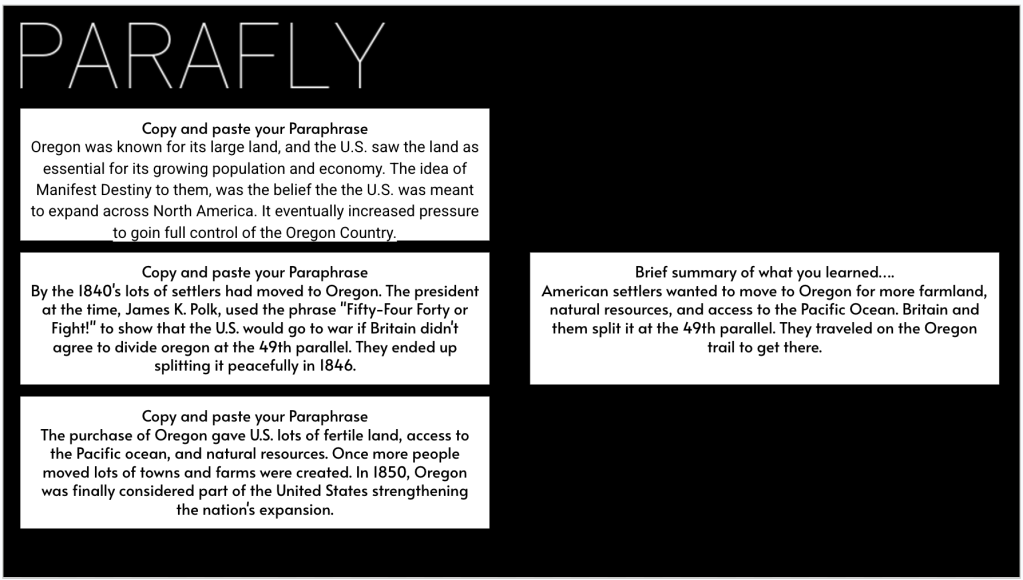
Parafly: Mastering Paraphrasing
Since the textbook’s explanation of Oregon was dense and overly wordy, I had AI break it into three digestible paragraphs. Using Socrative, I shared one paragraph at a time, and students paraphrased and submitted their responses.
- Round 1: Students had four minutes to paraphrase the first paragraph. To help those who struggled, I provided a cheat sheet (generated with AI) that highlighted key words to keep and suggested substitutions for complex terms.
- Round 2: I shared the second paragraph, gave quick feedback, and students paraphrased again—this time, they were faster.
- Round 3: By the third paragraph, students had built confidence and speed in paraphrasing.
After each round, students copied and pasted their paraphrases into a Google Slide, where they also wrote a three-sentence summary of what they learned about Oregon.
Map and Tell
To visualize the territorial dispute, we completed a Map & Tell activity that helped students grasp the meaning behind the slogan “54°40′ or Fight.” Using a historical map, students marked key locations and boundaries to understand the tensions between the U.S. and Britain over Oregon Country. They starred the 54°40′ latitude, which was the northernmost boundary some Americans wanted to claim. Then, they used colored lines to map the dispute, drawing a red line at 54°40′ to represent the aggressive claim and a green line at the 49th parallel, which became the actual U.S.-British border agreement. This hands-on approach reinforced why “54°40′ or Fight” was a powerful rallying cry but ultimately not the reality of the final negotiation.
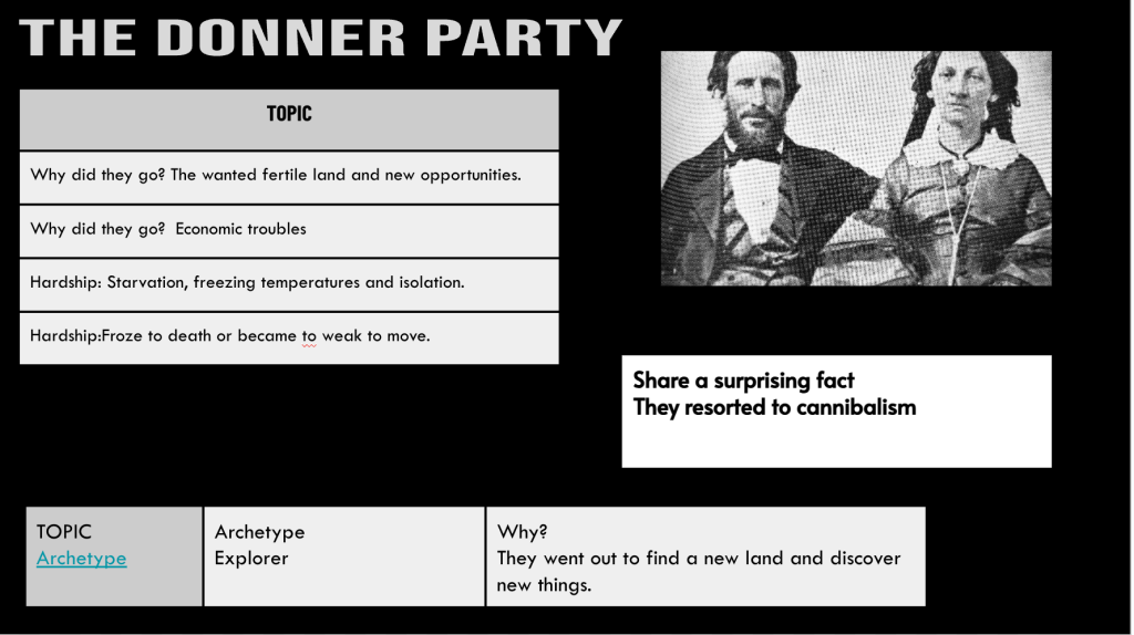
Thick Slide: Life on the Trail
Next, students chose one of two groups that traveled west:
- The Donner Party
- Mountain Men
They created a Thick Slide covering:
- Who they were
- Why they went west
- The hardships they faced
Oregon Trail & Final Review
To wrap up, we ran the same Gimkit for two minutes—this time, scores jumped significantly. Then, I shared a link to the classic Oregon Trail game online, letting students explore the challenges of westward expansion in a fun, interactive way.
This lesson balanced retrieval, paraphrasing, and content creation, reinforcing key ideas about why people moved west and the struggles they endured.


Friday
To get students thinking about the Texas Revolution on a personal level, I started class with this question:
“Have you ever agreed to something—only for the rules to suddenly change? Or, maybe you realized it was unfair? How did you react?”
This simple question helped students connect historical events to real-life experiences, making them more engaged from the start.
EdPuzzle for Background Knowledge
Before diving into the details, students watched a 7-8 minute EdPuzzle video about the Texas War for Independence. I use these short videos to provide a visual foundation and background knowledge before we break things down further.
MiniReport and Class Companion
For the main lesson, we used the MiniReport EduProtocol to structure our analysis of Texas’ independence and annexation. I took the textbook sections on Texas and split them into two sources:
- Source 1: Americans Rebel in Texas
- Source 2: The Lone Star Republic and Annexation
Students had 8-10 minutes to gather information from both sources. They paraphrased ideas and recorded key points without needing to write in full sentences.
Each student then summarized the main idea of what they gathered in their own words.
Once their notes were complete, they wrote a quick paragraph about Texas’ fight for independence and its annexation into the United States.
To wrap up, students submitted their writing into Class Companion for immediate AI-generated feedback. Since we ran out of time, we’ll finish refining and improving their responses next week.
